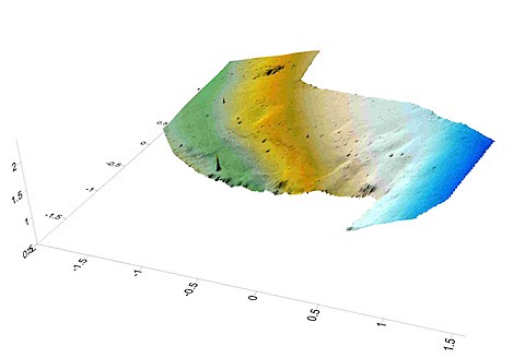
Using the work of BinaryMillenium I grabbed the bin files that were used to generate the photosynth for one of the Easter Island projects (a series of blimp photographs taken along the slope of Rano Rarku, the statue quarry. That synth can be found here: Rano Raraku - Interior Using the python script, I converted the point cloud data into XYZ data and then used Surfer to generate a surface from those points. My goal was to see how well photosynth might be used to generate topographic maps of landscapes. I had to cut out areas where there were spurious points and areas that were not well covered by the photos. Interestingly, the result is pretty good, though Ill have to do more analysis to compare these results with those from other topographic data generation techniques. Very promising! Best of all, photosynth seems to work best the greater the topographic structure -- cases that are tough (and expensive) to map by transit.
5 comments:
I would be interested to hear how you deal with finding an optimum translation/rotation and scaling to compare with other DEM products when you get to having at look at this.
I have also made a DEM from the point cloud and have found the results impressive but it would be great to compare these with other datasets in a differing coordinate space.
I've got three synths of aerial data with fairly decent overlap. I'd be interested in trying this technique in order to extract digital elevation data from the point clouds. One in particular has lots of 3D relief, and has been sampled fairly closely.
Would you be able to describe your workflow in more detail? I've got another package I'm using to deal with the point clouds, but the process of getting from synth to point cloud CSV file is a little opaque to me at the moment.
Thanks,
Tom
Some great potential here! I am a grad student in the Geography Department at the University of Maryland Baltimore County. I think this type of technology may be a good addition to remote sensing and I am trying to determine how much detail within the landscape might be resolved using synths. Are you still working on this stuff?
Jonathan
I am continuing to work on this. We've been working on figuring out the precision of the models by mapping an area already covered by LiDAR. We should have some results soon. Im also optimizing a blimp camera rig so that we can consistently shoot photos with overlap and with decent precision on the gps location of the cameras.
Ill outline a more detailed set of instructions of how to do this -- there are a couple of scripts that make the process a little easier.
This is really interesting stuff.
A couple of things spring to mind. Would this would work with good Photosynth data taken on foot from the ground? If so would things like long grass play havoc with the point cloud? I'm assuming if would try and map the grass as ground.
Look forward to seeing what you can do with this
Post a Comment