Friday, May 28, 2010

Rehydroxylation Dating (RHX): The Experiments Begin...

While there are still things to do -- such as transporting massively heavy granite balance table to the lab (via a door blocked by construction and a forklift and somehow squeezing into the doorways of the Microbiology building) -- the RHX Dating lab is coming together and we are beginning to conduct our experiments. This week we had a TA Instruments VTI-SA vapor sorption analyzer and a Q50 thermogravimetric analyzer (TGA) installed into the IIRMES lab. The installations went smoothly though we lacked the giant balance table and had to use a bench top that is a bit less than optimal.
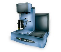

201005281749.jpg The Q50 is a nice little TGA. Completely controlled via Windows (man, I do not miss the SCO Unix OS and software that ran on the Perkin Elmer TGA we had back at the U.W.) with a nice 1gm maximum sample size and a furnace that covers 0-1000 degrees C. My primary impetus for purchasing the TGA is for determining firing temperatures on prehistoric ceramics to see how this factor may impact rehydroxylation processes. From my initial test of a Mississippian sherd from Arkansas (Rose Mound), the unit will be ideal -- I got a clear signal at ca. 610 degree C that showed a massive loss of weight that is the result of additional firing of the clay beyond the original firing temperature. I'll be running more tests, of course. And I need to do some work on the various exceptions of clay composition and firing effects.
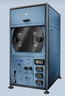
201005281750.jpg The vapor sorption analyzer is a 1950s looking machine but has a solid Windows based interface for doing all of the actual work. Basically it consists of an ultra balance with two sample holders that are suspended in a finely controlled temperature and humidity environment. For our purposes, much of the ability (to change temp and humidity in a dynamic way) of the VTI-SA are overkill since our use basically consists of making mass measures in a constant temperature and humidity -- but the precision of this instrument will give us an ability to explore some of the boundaries of the overall method. We are now working on our measurement protocols so we can start running sherds -- Ill probably go in tomorrow to start a run. Can't wait...

Thursday, May 27, 2010

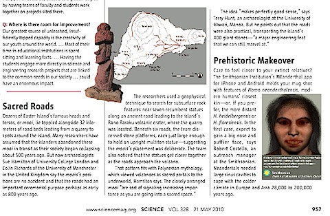
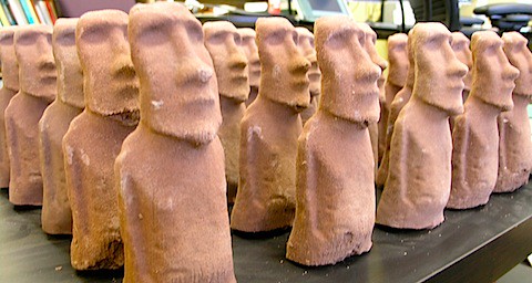
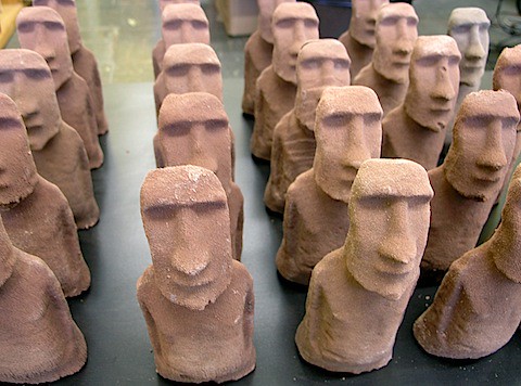
Moai Roads

A recent news blurb in Science described work by Sue Hamilton and Colin Richards of the University of Manchester that apparent refutes the ideal that the "roads" observed on Rapa Nui are actually related to the statue transport. Their claims are based on (as I understand it -- since there is no actual published article yet, just a press release from their recent season) some geophysical measures made at locations where fallen statues are located along the road. From what I have gleaned, these measurements show evidence of "platforms" that are buried at the position of the bases of statues. The claim made by Hamilton and Richards is that these platforms are evidence that the statues are not evidence of failure during transport, but toppled moai that once lined a processional route that led to the quarry. These routes, they argue, are consistent with a bunch of Polynesian lore in which volcanos are special places.

There are a number of problems with their claims:

(1) They haven't published anything: the Science blurb is based on a press release that they did. Given that these releases are written by PR folks at the university, it is unclear how what they say is related to what archaeological evidence they have, if any. The PR folks are going to make whatever they did into the most sensational story ever -- that's there job. In fact, given that their findings were releases as a press release, I'm fairly shocked that Science even bothered to cover the story -- nothing that they said has been subject to any degree of peer evaluation.

(2) The argument about Polynesian mythology is just made up storytelling. There are lots of Polynesian myths, all of which could be crafted in ways to account for statues arranged in the way they are. Are these positioned to lead people to the ocean? Are they ancestors that over look fields? Are they territorial markers (as argued by Brett Shepardson)? Lots of things are possible and what Hamilton and Richards claim is a heap of mumbo jumbo. This is the worst kind of post-processualism -- empiricist claims interpreted through ad hoc interpretations. Science should be chastised for highlighting this story. In a previous story (in the fall), Hamilton and Richards released a press release about how they found the "pukao" quarry. This press release was equally filled with mumbo jumbo and demonstrated a shocking lack of awareness of the literature.

(3) Statues had to be moved in some way since we know they originated from the quarry at Rano Raraku. This isn't storytelling: we know that they were made at the quarry and we know they were moved. Were they moved down paths other than the ones that they are found?

(4) The statues that are raised on platforms uniformly have eyes carved in them. None of the quarry or "in transit" statues have this feature.

(5) Whatever "platforms" the moai sat on that are found on the roads, these are not ahu - substantial structures built to be the bases for statues. So these "platforms" are just some rocks on which the statue sat - perhaps for stablization during movement?

(6) We don't know where Hamilton and Richards did their geophysical work (i.e., which statues). If the statues are near the quarry, there are other reasons to expect some kind of stablized base having to do with finishing the backs of the statues after sliding them down the slopes of the quarry.

(7) Richards and Hamilton seem to be stuck on the notion that the statues were transported via rollers - and that the "u shape" (noted by Charlie Love previously in excavations) falsifies this transport method (also noted by Charlie Love).

I could go on - but of course lacking an actual publication about the work I'd be speculating what they did and what they found.

201005261832.jpg  

Monday, March 22, 2010

Visualization of Today

787 billion dollars to track. Graphs to make. If anyone can do it, Edward Tufte can: he's the data visualization superhero. Read about him taking on the ARRA stimulus package.

Sunday, March 21, 2010

Archaeology at CSULB

Proceedings are on-going for the admission of archaeology graduate students at CSULB for the fall 2010. Stay tuned.

Graphical perception – learn the fundamentals first | FlowingData

Came across this discussion of Cleveland and McGill's work on Flowing Data regarding visualization of data. Things to keep in mind.

When it comes to visualization, especially on the Web, you have to be open-minded, and you should be willing to try new things. There’s no advancing otherwise. However, before you dive into the advanced stuff - like just about everything in your life - you have to learn the fundamentals before you know when you can break the rules.

perception.1krjbgaaam74k04ckkgkwg0k0.bxj7bs82axw0g448owg4gc8so.th.png

[From Graphical perception – learn the fundamentals first | FlowingData]

Saturday, March 20, 2010

What you do need to know before you enter a graduate program in archaeology.

Previously, I argued that traditional field skills are not anything to worry about before entering a graduate school: you can always learn how to dig a hole. Now, you might ask, what skills should I have? Here's the list, based on what I've seen graduate students struggle with during their first years. Having these skills under control will greatly ease your first years and give you time to focus on learning actual archaeology rather than basic mechanics. You might also check out my previous post on my advice for graduate students.
(1) Be able to write. The better you are at writing, the easier your graduate school experience will be, especially in the first few years. In all of your classes you will be asked to write: essays, papers, laboratory write ups, analyses, reviews, etc. Writing is a key part of graduate school. In fact, its basically the product of archaeology. At our core, we are writers who happen to rummage around in dirt, speak conceptually about rocks and other kinds of inanimate things. The better you are at writing, the better an archaeologist you will be. Before you start graduate school, do some writing. Start a blog and keep it current. Turn a paper you wrote as an undergraduate into something for publication - whether that is a newsletter, local publication, regional venue or greater. Take a class in writing at your local community college. Read Strunk and White's Elements of Style. Then read it again. Then read On Writing Well, by William Zinsser. Then practice some more. Make your writing logically sound. Clear. Sharp. Readable.
(2) Learn how to use Microsoft Excel or any equivalent spreadsheet program (whether that be OpenOffice, Gnumeric, Numbers or some other variant). Given that contemporary students are often touted as being terrifically "computer savvy" with all of that YouFace, FaceTube and Twitface stuff, I am incredibly appalled that many entering archaeology students have never used a spreadsheet. I've seen students, for example, enter numbers into a spreadsheet as instructed and then do calculations on a calculator (e.g., summing the values) and then entering the results back into the spreadsheet. Really. Given that much of what we do in archaeology in addition to writing is counting things, have advanced knowledge of Excel will go along way to making your assignments be about the problems posed and not the mechanics of dealing with numbers. Trust me on this one. Learn how to use a spreadsheet, create headers, use autofilter, use functions, create formulas, create graphs, do basic statistics, etc. Equally important: learn how to edit the graphs and tables produced by Excel to make them acceptable. Don't rely on the defaults. Learn to identify "chartjunk" and maximize the information to ink ratios for your graphics. tufte_wallpaper.2vf33bt6eq0wc0scws0kg04kc.bxj7bs82axw0g448owg4gc8so.th.png
(3) Know the basics of statistics. If you count, describe or measure things, you need to understand statistics simply because all of the actions are meaningful only if one understands the contribution of error. Don't hide behind some claim of "phobia" about numbers: if this is really the case, choose another career. Really. If you really are unable to understand the concept of a standard deviation, do society a favor and pick a more suitable career like crematorium manager or whatever. And while you will learn more about statistics in graduate school, if you don't know anything about the basics you will be wasting everyone else's time as you get up to speed. Take an extension class. Read a book on statistics and do the exercises. Practice. Count things, calculate error. Just learn statistics.
(4) Learn some kind of programming language. Some might argue with me about the fundamental nature of this skill, but I definitely believe that every archaeologist should learn at least on kind of programming language: Perl, Basic, Visual Basic, Python, C, C++, C#, shell scripting, Java, Javascript. It really does not matter which language one chooses, but the skills acquired through learning how to take a problem and break it down into simple steps that can be coded will provide a generous payoff for anyone tackling the routine problems facing archaeology students (and professionals alike). Programming is more of a logic problem than anything else and learning how to conceive of problems that can be tackled via a program is a good demonstration that you can figure out how to solve problems in general. And having the skills to program means you are not going to waste your life doing tedious things that you (a) not do well and (b) you shouldn't be doing by hand in the first place. For example, given a large number of files (say 10,000) rename them according to some scheme. If your only solution is to do this take one by one and by hand, you are in trouble. Take a class. Read a book. Do online exercises. Learn some kind of programming. And do it before you are in graduate school.
(5) Learn something about GIS. In graduate school, you will definitely have opportunities to learn something about spatial systems. However, you should gain a background in the basics of geographic systems before you start graduate school. GIS is really just a different kind of computer application - like Word or Excel - that allows you to manipulate concepts in space. No archaeologist worth her/his salt should lack an understanding of GIS. And that means you. The more you know about GIS - like using Word or Excel, the easier it will be to focus on archaeological analyses that deal with space rather than the mechanics of the various program that you are going to use to study space. Learn ESRI's ArcGIS or the open source Quantum GIS or one of many other geographic information systems.
Well, that is a start that should keep you busy for the summer prior to starting a graduate program in archaeology. As I recall other critical skills, I'll update this list. If you have any ideas, please let me know.