While we are still doing edits on the manuscript, our Rapa Nui/Easter Island book has now become available on Amazon for pre-orders. Pre-order your copy here! Order now and we will throw in a free set of steak knives or a personalized signed note!
Tuesday, November 16, 2010


Friday, November 12, 2010
Structure From Motion
Part of our interest in acquiring a UAV is to expand our ability for quickly generating high resolution topographic data. Traditionally, this process is time-consuming and (as a result) expensive. I've spent a number of summers collecting elevation data over archaeological deposits (Easter Island, Panakton, Greece, Harappa..) and even after weeks of tedious point collection (and thousands of points measured across the ground), the resulting topographic map is less-than-desirable. The problem is one of data density -- 1000 points can be collected pretty quickly (esp. with a modern total station) but over any sized area the density of the points is pretty low per unit area. Take a 100x100 meter area -- it would take 10000 points to have a point every meter. 1000 points is only a 10% sample of that. Now one can be "smart" and sample more densely in areas with greater changes in topography but then some of the algorithms for building the iso-contours will produce odd "artifacts" -- many assume even coverage of points. Even with 10000 points, you end up with a fairly crude representation of the surface - which might work at the scale of the entire deposit, but is too crude for examining any specific area. To make matters worse, in order to increase resolution by say 2x (i.e., to get 50 centimeter resolution), you have to quadruple the sample size.
New developments in laser scanning and LiDAR provide a great means for changing the data generation to cost relationship. However, the technology is pretty new and not entirely cheap. Ultimately, LiDAR provides a great solution for mapping landscape scale features (e.g., entire states) and produces information about the bare ground (so can provide topographic data under tree canopies -- often where we know the least about the archaeological record [e.g., bayous]). But for a project specific survey LiDAR can be overly expensive or simply impossible (since getting plane to some places with the right set up for laser scanning is not always possible -- e.g., Easter Island). Here, land-based laser scanners are handy but these cost about $100,000 to start and typically require trained operators. Renting them can be as much as $20K a month.
From a cost perspective, generating topographic information using "structure from motion" based techniques is quite appealing. This approach makes use of basic imagery collected from inexpensive cameras. Surfaces are calculated based on shared points in photos, determining the position of the camera from images and calculating where the points that are shared must be in space in order that they were captured by the camera. It is an ingenious technique - using some cool math. Noah Snavely, a PhD student (now an assistant professor at Cornell) at the University of Washington developed some of the basic software for doing this (originally part of a "photo tourism" project in which photos taken by tourists of locations can be combined to build a 3-D model of the scene - without knowing before hand where the cameras were placed and under a variety of lighting and other conditions). This project has morphed into Photosynth, the free Microsoft project that automates this project and is Silverlight based.
From a topographic perspective, the "structure from motion" approach is pretty slick - using just a bunch of photos made on cheap digital cameras, one can produce detailed representations of surfaces. Actually, the product is a 3D point cloud that has excellent relative accuracy. Increasing resolution simply means more photos - and whole swaths of areas can be covered with just a click of the shutter. Getting absolute position requires georectification - a separate process (which I can detail elsewhere). Commercial products, though, can take geotagged photos and create a georeferenced point cloud. We have a license for Microsoft's Geosynth - a professional version of Photosynth that can take HD video and geotags to produce high density georeferenced point clouds.
One of the problems with Geosynth, however, is that it doesn't produce some basic products such as a simple (georeferenced) photomosaic. Instead, there focus is on creating "synths" -- a cool product but entirely unintegrated with other kinds of spatial tools (e.g., GIS). Last week, we saw a demo of another software package that produces mosaics using the same kinds of algorithms as Geosynth -- 2d3's TacitView. 2d3 is a small software company located in Irvine. TacitView (and TopoMap, their 3D product). The software is slick and well-done - a great interface and the products are well-suited for integrating into GIS software. We are going to do a demo of this software soon to see how it compares to Geosynth.
Thursday, November 11, 2010
UAV
We finally made the plunge and send out a PO for a UAV (unmanned aerial vehicle). Of course, we are not talking about a GlobalHawk or a Predator drone (but man, those would be cool -- do field mapping on the other side of the planet from a desktop... drool). We are looking to get a (1) robust (2) self piloting (3) portable (4) minimally dangerous to others (5) robust (6) really robust (7) affordable platform for generating high resolution imagery of land surfaces that can be turned into georectified orthophotos (ideally with multi-spectral capability) and high resolution topographic information. The UAV we want has GPS guidance, returns to launch location, and will allow systematic coverage of a landscape. This rules out most helicopter solutions that specialize in "overhead" type coverage. While there are *many* fixed-wing based UAVs out there for potential sale, most of them tend to be military oriented and thus too expensive or unattainable (i.e., why bother with a university when uncle sam will buy a billion dollars worth of your product).
We initially had made a deal with DraganFly to buy their Tango platform. In fact, we went so far as to do a PO for their fixed wing system. However, we found out a number of details (1) DraganFly isn't really making Tango type platforms, at least for the near future as they are focusing almost entirely on the helicopter type units (2) when they list "gps guidance" in their specs what they really mean is that they have a "solution" for gps guidance provided by another company that requires an entirely separate license and other negotiation. In other words, they simply can't deliver a fixed wing system. Bogus.
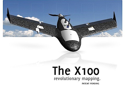
We ended up going with Gatewing, a Belgian startup company that has created a UAV system ideally suited to our purposes: generating systematic imagery to be used in creating orthophotos and terrain maps. Their system is the "X100" and meets all of our requirements -- and will ship on December 13th! Whoohooo. At any rate, this platform should gives an excellent means for generating topographic maps of study areas and for producing detail photographic imagery. We look forward to working with Gatewing and exploring this UAV's capability.
Monday, November 1, 2010
Philosophical Transactions of the Royal Society B
Ethan just let me know that the special issue of the Philosophical Transactions of the Royal Society B -- edited by James Steele, Peter Jordan and Ethan Cochrane is now available online.
Cultural and linguistic diversity: evolutionary approaches

Recent work has shown that language and other human cultural practices can be considered as evolutionary systems operating on the Darwinian principle of 'descent with modification'. An emerging field of interdisciplinary science builds on phylogenetic and other methods adopted from biology, and adapts them to explain the transmission histories of suites of cultural traits (whether languages, social structures, or artefacts). This theme issue asks what social processes lead to coupled and decoupled transmission of different cultural traits or suites of traits, and how their transmission histories can be estimated retrospectively using quantitative methods. Understanding the factors affecting descent histories is central to explaining how cultural diversity arises and how it is maintained. These questions are of interest and relevance not just to social science and evolutionary theory, but also to planners working on topics such as endangered language maintenance.
Thursday, October 28, 2010
RHX Status Update
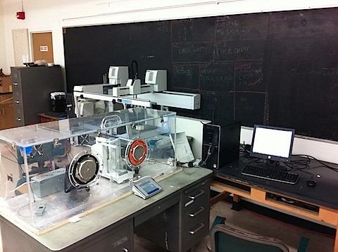
We've got the basis for the RHX environmental chamber -- temperature and humidity controller as well as a Mettler XP56 balance. The XP56 has a 50 gram capacity and weighs to 1 microgram. We've insulated the acrylic environmental box to help with the temperature control. A cheaper version of the box could probably be made of sealed styrofoam with a little window -- but we had access to an already constructed glove box. Temperature is controlled to 0.1 degrees C using 3 thermoelectric peltier coolers. For the humidifier we use a commercial cigar humidor.
On another front, we finally got a solid date for a Plumbate sherd -- 1153 BP.
Tuesday, October 5, 2010
A bit of a diversion
Over the past several months, Mark Collard has posted a number of YouTube videos on topics related to science, evolution and general irreverence. They are all humorous and great diversions from otherwise bleary days. I thought I'd aggregate them plus some others for your watching/listening pleasure.
- The Sound of Science (Wendy Dirks)
- The Pope (Tim Minchin)
- Storm (Tim Minchin)
- Science is Real (TMBG)
- Put it to the test (TMBG)
- Cells (TMBG)
- Mammal (TMBG)
Wednesday, September 29, 2010
Posing Questions for a Scientific Archaeology
A long time ago, in a galaxy far, far away (well, it was Seattle) there were a group of students in an archaeology graduate program (at the University of Washington) who shared a particular kind of training offered by a curmudgeonly but deeply logical professor (Robert C. Dunnell). These students all spent significant amounts of time preparing proposals for conducting their doctoral research. The challenge they faced was dictated by their advisors: conduct archaeological research that will generate falsifiable answers to questions about the archaeological record. This task is harder than it seems since the first task, asking appropriate questions, has been a quagmire for archaeologists since the origins of the discipline. Yet, to finish their PhDs in this particular program, these students naively took on this challenge and spent years (in many cases) developing their proposals.
In the end, most of the students finished their PhDs by conducting the research that was proposed. The resulting tomes can be found in the UMI repository and in some cases as published volumes. One of the important contribution of their work, however, isn't entirely in the end product. In the end, the results of the research are all determined by the questions being asked and the proposals generated dictating the research design. These documents rarely see the light of day in a publication sense yet are the fundamental basis upon which data are generated and conclusions drawn. Indeed, not all of the students completed their research (largely due to the difficulties involved in actually making the required measurements) but even so, the proposals for the work stand alone as significant accomplishments. In science, asking the right questions is the 99% of the problem.
With Terry Hunt (University of Hawai'i) and Sarah Sterling (Portland State University), I put together an edited volume of these proposal. This book was published back in 2001 by Bergin and Garvey. You can still buy it new off of Amazon.com (http://www.amazon.com/Posing-Questions-Scientific-Archaeology-Millennium/dp/0897897536) for an absurd amount of money ($119) or you can get it used for as little as $10.00. You can even preview the book at books.google.com
The table of contents of Posing Questions.:
Preface
Chapter 1: Posing Questions for a Scientific Archaeology - Terry L. Hunt, Carl P. Lipo and Sarah L. Sterling
Chapter 2: Groundstone Wedge Tool Form and Function: Experimental Analyses in Northern South American “Axes” - Kimberly D. Kornbacher
Chapter 3: The Engineering and Evolution of Hawaiian Fishooks - Michael T. Pfeffer
Chapter 4: Projectile Point Variation in Evolutionary Perspective: An Example from the Central Mississippi River Valley - Kris H. Wilhelmsen
Chapter 5: Social Complexity in Ancient Egypt: Functional Differentiation Reflected in the Distribution of Standardized Ceramics - Sarah L. Sterling
Chapter 6: Community Structures in Late Mississippian Populations of the Central Mississippi Valley - Carl P. Lipo
Chapter 7: Dietary Variation and Village Settlement in the Ohio Valley, A.D. 400 - 1650 - Diana M. Greenlee
Chapter 8: Resource Intensification and Late Holocene Human Impacts on Pacific Coast Bird Populations: Evidence from the Emeryville Shellmound Avifauna - Jack Broughton
Chapter 9: Evolutionary Bet-Hedging and the Hopewell Cultural Climax - Mark E. Madsen
Index
Contributors
Given that Terry Hunt, Sarah Sterling and I hold the copyright, I'm going to link a PDF of this volume. I am releasing this under a Creatives Commons Licence. You can download the book here (about 17 megs).
This work is licensed under a Creative Commons Attribution-NonCommercial-ShareAlike 3.0 Unported License
Subscribe to:
Posts (Atom)